Contents
- 🎵 Origins & History
- ⚙️ How It Works
- 📊 Key Facts & Numbers
- 👥 Key People & Organizations
- 🌍 Cultural Impact & Influence
- ⚡ Current State & Latest Developments
- 🤔 Controversies & Debates
- 🔮 Future Outlook & Predictions
- 💡 Practical Applications
- 📚 Related Topics & Deeper Reading
- Frequently Asked Questions
- References
- Related Topics
Overview
The phenomenon of tsunamis has been documented across human history, with early accounts often attributed to divine wrath or mythical sea monsters. However, scientific understanding began to coalesce in the 19th century. The devastating 1896 Sanriku earthquake and tsunami in Japan, which claimed over 26,000 lives, spurred significant research into seismic activity and its oceanic consequences. The 1960 Valdivia earthquake in Chile, the most powerful earthquake ever recorded at magnitude 9.5, generated a trans-Pacific tsunami that caused fatalities as far away as Hawaii and Japan, underscoring the global reach of these events. The International Tsunami Information Center (ITIC) was established in 1965 under the auspices of the UNESCO to coordinate global tsunami warning efforts, building on earlier systems developed by the NOAA in the United States.
⚙️ How It Works
Tsunamis are born from a sudden, large-scale disturbance that vertically displaces a significant water column. The most frequent cause is a powerful undersea earthquake, particularly those occurring at convergent plate boundaries where one tectonic plate subducts beneath another, leading to a sudden uplift or subsidence of the seafloor. This seafloor movement transfers energy to the overlying water, initiating a series of long-wavelength waves. Other triggers include the collapse of volcanic islands into the sea, massive submarine landslides, and, rarely, large meteorite impacts. These waves propagate outwards from the source, maintaining their energy over vast distances, unlike surface waves which dissipate more rapidly.
📊 Key Facts & Numbers
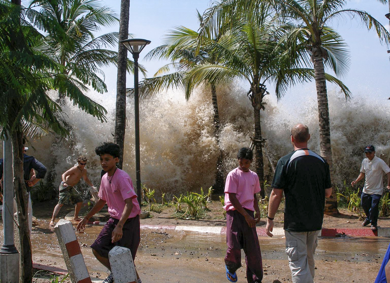
The destructive potential of tsunamis is staggering. The 2004 Indian Ocean tsunami, triggered by a magnitude 9.1–9.3 earthquake, is estimated to have killed over 230,000 people across 14 countries, making it one of the deadliest natural disasters in recorded history. Waves from this event reached heights of up to 30 meters (100 feet) in some areas. The speed of a tsunami in the deep ocean can exceed 800 kilometers per hour (500 mph), comparable to a commercial jetliner. The wavelength can span hundreds of kilometers, meaning that the entire water column, from surface to seafloor, is in motion. The energy contained within a single tsunami wave can be immense, equivalent to that of multiple nuclear bombs.
👥 Key People & Organizations
Key figures in tsunami research include seismologists like Charles Richter, who developed the magnitude scale bearing his name, crucial for understanding earthquake potential. Katsuyuki Kajiura made significant contributions to the mathematical modeling of tsunami propagation. Organizations such as the NOAA's Pacific Tsunami Warning Center (PTWC) and the Japan Meteorological Agency (JMA) are at the forefront of real-time tsunami monitoring and warning dissemination. The UNESCO Intergovernmental Oceanographic Commission plays a vital role in coordinating international tsunami warning systems and promoting preparedness, working with national agencies and research institutions worldwide.
🌍 Cultural Impact & Influence
Tsunamis have profoundly shaped coastal cultures and human settlement patterns. The constant threat has led to the development of sophisticated warning systems, evacuation protocols, and architectural adaptations in vulnerable regions like Japan and the Pacific Islands. The iconic woodblock print 'The Great Wave off Kanagawa' by Katsushika Hokusai (c. 1830-1832) is perhaps the most famous artistic depiction, capturing the awe-inspiring and terrifying power of these waves. The sheer scale of destruction from events like the 2004 Indian Ocean tsunami has also spurred global humanitarian efforts and international cooperation in disaster response, influencing disaster management policies worldwide.
⚡ Current State & Latest Developments
Current tsunami warning systems rely on a network of seismic monitoring stations, ocean-bottom pressure sensors (like the Deep-ocean Assessment and Reporting of Tsunamis, or DART system), and coastal tide gauges. These technologies allow for rapid detection of potential tsunami-generating earthquakes and provide data to forecast wave arrival times and heights. Following the 2004 Indian Ocean tsunami, significant investments have been made to expand and improve these systems, particularly in the Indian Ocean region, which had historically lacked a comprehensive warning infrastructure. Ongoing research focuses on improving the accuracy of wave height predictions and the speed of alert dissemination to at-risk populations.
🤔 Controversies & Debates
One persistent debate revolves around the term 'tidal wave.' While colloquially used, it is scientifically inaccurate as tsunamis are not caused by tides, which are driven by lunar and solar gravity. Another area of contention is the accuracy and timeliness of warning systems, particularly in regions with limited infrastructure or where communication can be hampered by the disaster itself. The effectiveness of public education and evacuation drills is also a subject of ongoing evaluation, as human behavior during a crisis can be unpredictable. Furthermore, the long-term environmental and economic impacts of tsunamis, including coastal erosion and the disruption of marine ecosystems, are subjects of continuous study and debate.
🔮 Future Outlook & Predictions
The future of tsunami preparedness hinges on advancements in detection technology, improved modeling capabilities, and enhanced community engagement. Researchers are exploring the use of artificial intelligence and machine learning to analyze seismic and oceanic data more rapidly, potentially reducing warning times. The development of more resilient coastal infrastructure, including natural defenses like mangrove forests and engineered barriers, is also a key focus. International cooperation in data sharing and joint exercises will remain critical for effective global tsunami mitigation. The potential for increased frequency or intensity of tsunamis due to climate change-induced glacial melt or altered seismic patterns is a subject of ongoing scientific inquiry.
💡 Practical Applications
Tsunami warning signs are a critical practical application, often featuring stylized wave imagery and directional arrows to guide people to safety. Evacuation routes are clearly marked in vulnerable coastal zones, and public awareness campaigns educate residents and tourists on natural warning signs, such as the rapid recession of the sea. In Japan, extensive seawalls and other coastal defenses have been constructed, though their effectiveness against the largest tsunamis remains a subject of engineering assessment. The development of early warning systems has allowed for timely evacuations, saving countless lives in events like the 2011 Tōhoku earthquake and tsunami, where warnings were issued minutes after the earthquake.
Key Facts
- Year
- Ongoing phenomenon, scientific study intensified from 19th century
- Origin
- Global (primarily Pacific Ring of Fire, Indian Ocean, Atlantic coastlines)
- Category
- nature
- Type
- phenomenon
Frequently Asked Questions
What is the difference between a tsunami and a tidal wave?
The term 'tsunami' is scientifically accurate, referring to a series of waves caused by the displacement of a large volume of water, typically due to earthquakes or volcanic activity. 'Tidal wave' is a misnomer, as tsunamis are not related to the gravitational pull of the Moon and Sun that causes tides. While colloquially understood, scientists and researchers strongly prefer the term tsunami to avoid confusion with actual tidal phenomena.
How fast do tsunamis travel?
In the deep ocean, tsunamis can travel at speeds comparable to commercial jetliners, often exceeding 800 kilometers per hour (500 mph). As they approach shallower coastal waters, their speed decreases significantly, typically to around 30-50 kilometers per hour (20-30 mph). This reduction in speed causes the wave's energy to be compressed, leading to a dramatic increase in its height.
What are the most common causes of tsunamis?
The overwhelming majority of tsunamis are generated by large undersea earthquakes, particularly those occurring at subduction zones where tectonic plates collide. Other significant causes include underwater volcanic eruptions, submarine landslides (which can be triggered by earthquakes), and, rarely, large meteorite impacts. The key factor is the sudden vertical displacement of a substantial volume of water.
What should I do if I suspect a tsunami is coming?
If you are in a coastal area and experience a strong earthquake that makes it difficult to stand, or if you notice the ocean rapidly receding from the shore, treat it as a natural tsunami warning. Immediately move to higher ground or inland as far as possible. Follow instructions from local emergency officials and heed any official tsunami warnings or evacuation orders. Do not wait for an official announcement if natural signs are present.
Are tsunamis predictable?
While the exact timing and magnitude of the events that cause tsunamis (like earthquakes) are not predictable, the occurrence and potential impact of tsunamis after a triggering event are predictable to a degree. Modern tsunami warning systems, utilizing seismic sensors and ocean buoys, can detect potential tsunami-generating earthquakes and forecast wave arrival times and approximate heights for coastal areas. This allows for timely evacuations, significantly reducing casualties, as demonstrated by the 2011 Tōhoku tsunami response.
How can coastal communities prepare for tsunamis?
Preparation involves a multi-pronged approach. This includes developing and practicing evacuation plans, establishing clear evacuation routes and signage, and educating residents and visitors about natural warning signs. Building resilient infrastructure, such as seawalls and elevated structures, can mitigate damage. Maintaining natural coastal defenses like mangrove forests is also crucial. International cooperation and robust early warning systems are vital components of comprehensive tsunami preparedness.
What is the largest tsunami ever recorded?
The largest tsunami wave ever recorded in terms of height was not a true oceanic tsunami but a megatsunami caused by a massive landslide into Lituya Bay, Alaska, on July 9, 1958. The landslide generated a wave that surged up the opposite mountainside to an astonishing height of 524 meters (1,720 feet). For oceanic tsunamis, the 2004 Indian Ocean tsunami and the 2011 Tōhoku tsunami are among the most devastating and widespread in recorded history, with wave heights reaching up to 30 meters (100 feet) in certain locations.